The area calculation of the plot means to find out the area of the geometrical shape comes in square feet or square meters. Each geometrical shape has its own formula to calculate area.
How To Perform Area Calculation?
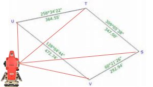
When performing area calculations for a plot using a total station, the process typically involves conducting a land survey to gather the necessary data.
Here’s a simplified overview of the steps involved.
1. Set up the total station.
Begin by setting up the total station at a known reference point on the plot. if you don’t have a reference point you can set it on any temporary benchmark. This involves ensuring the instrument is level and properly calibrated.
2. Conduct survey points.
Use the total station to measure the coordinates (typically in terms of distance and angles) of various points around the plot. These points should form a closed boundary around the area you want to calculate.
3. Collect data.
Record the measured coordinates for each survey point and ensure accuracy. You may need to take multiple measurements to minimize errors.
4. Calculate distances.
Use the measured coordinates to calculate the distances between consecutive survey points. This is typically done using trigonometric calculations.
5. Calculate the area.
Once you have the distances between the survey points, you can use the appropriate method, such as the Shoelace formula or the triangulation method, and press the CALC button to calculate the area of the plot. In the results using any total station for area calculation, the area shows up to you in square feet, square meters, and hectors on the screen of the total station.
6. Perform necessary adjustments.
Depending on the survey requirements and potential sources of error, you may need to apply adjustments, such as correcting for elevation differences or accounting for any measurement inaccuracies.
Conclusion
In summary, calculating the area of a plot using a total station is important in land surveying. Follow a systematic approach to set up the total station, measure points, collect data, calculate distances, and make necessary adjustments. Adhere to guidelines and consult professionals for accuracy.