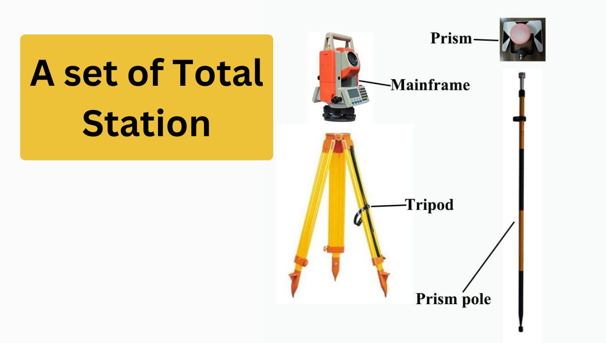
Traversing with Total Station

Traversing With Total Station

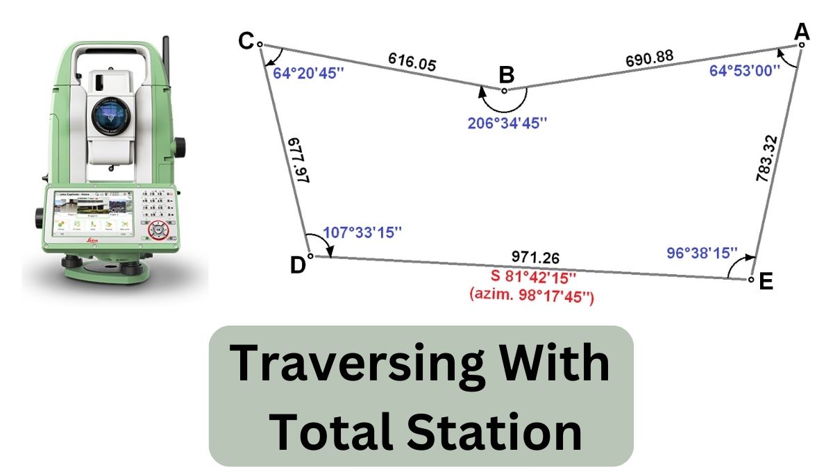
In this article, we will discuss traversing. Before traversing we need to know about traverse. A traverse is an uneven Geometrical shape that has more than four sides. if we have a geometrical shape and have three sides, we call it a triangle. If we have four sides so we call it a square or … Read more

Area Calculation of Plot With Total Station.

The area calculation of the plot means to find out the area of the geometrical shape comes in square feet or square meters. Each geometrical shape has its own formula to calculate area. How To Perform Area Calculation? When performing area calculations for a plot using a total station, the process typically involves conducting a … Read more

Leica Total Stations

leica flexline ts10

Leica Total Stations are highly regarded surveying instruments manufactured by Leica Geo systems, a well-known provider of advanced measurement solutions. Leica Total Stations combine precision optics, electronic distance measurement (E.D.M) technology, angle measurement, and data processing capabilities into a single device. Key Features Of Leica Total Station Here are some key features and functionalities of … Read more

Kolida Total Station & RTK System.

total station

KOLIDA is a Chinese surveying equipment company founded in 1989. They started as a small store in Guangzhou and quickly gained popularity among surveyors and engineers. They became a distributor of Japanese brands and developed their calculator and program for total stations. The instrument introduced innovative products like distance meters and theodolites. They later pioneered … Read more

Stakeout in Surveying. (Layout)

Stakeout with total station

Stakeout means marking the points that are shown on the drawing in an actual place. This is also called layout. In total station Surveying language, it’s called S-O. In stakeout we need to mark the point showing on the plan, that points may be for excavation or for leveling purposes. Importance of Stakeout (S-O). Layout … Read more

Total Station, Components and Basic Setting

Total station. a survey instrument

A total station is an advanced surveying tool that helps people measure distances, angles, and elevations accurately. It’s used in construction and land surveying to make maps, measure land features, and determine property boundaries. One person operates it using a controller or computer, with features like data storage and real-time data transfer. It’s constructive because … Read more

Resection Using Total Station.

how to resection using total station

Resection using total station is a process in which we can establish a new control point or benchmark from two or more than two existing benchmarks. Resection using Total Station. Resection can be done by two methods. 1. Resection by angle Resection by an angle is a surveying technique used to determine the location of … Read more

Total Station, Merits and Demerits.

A total station is a tool used to measure and record coordinates, and horizontal and vertical distances of land. It combines a measuring device that calculates distances with a tool that measures angles. It’s used in industries like construction and other civil engineering projects. Data from the total station can be sent to a computer … Read more

Surveying Codes That Are Commonly Used During Work.

surveying codes

In this article, we will discuss the Surveying codes that are commonly used. Land surveyors use standardized codes to communicate information about the features being surveyed, such as boundaries, contours, and elevation benchmarks. These codes allow for accurate data recording in the field, which can then be translated into detailed maps and plans for a … Read more