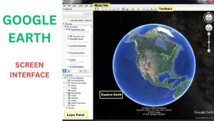
Google Earth is a software used to determine the places on the earth’s surface and used in our daily surveying work.
What is the zone in google earth?
The zone is defined as the specific area on earth space. can be a city, landmark, address, or any other geographical area you are interested in. By entering the name or address of a zone in the search bar, It will display and focus on that particular location, allowing you to view it on the map and explore its surroundings.
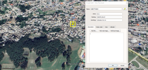
To find a zone, you need to write your desired place address in search option, the software will direct you on that place. After that you pin that point where you can see the exact location coordinates, the zone and the location address.
Latitude and Longitude of a Point
The latitude an longitude of a point is the location of a point from the origin. they are also named as easting and northing of a point. latitude is also called easting and longitude is named as northing.
The exact location of a point is find by its specific coordinates. and the coordinates of a point is the exact distance from the origin to easting and northing sides.
To find the coordinates of a point open software and search that point. zoom in that point. google will show you all aspects and details of that place. pin that point. after that google will give you the exact latitude and longitude and also the point zeenat or level.
Where can we download this Software?
The software is available in app and you can also find it on web browser.